MGB-8 calls on LGUs to
look into irregularities that aggravate flooding
By Philippine Information Agency (PIA 8)
September
30, 2011
TACLOBAN CITY –
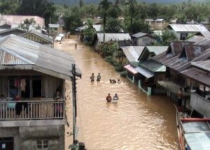
Improper extraction of sand and gravel at the river banks of Catarman
River, rampant cutting of trees and improper disposal of waste into
the river are the main factors that aggravate flooding in various
barangays of the municipality of Catarman, Northern Samar, Chief
Geologist James Leones, the head of the Mines and Geosciences Bureau
10K survey team, observed.
 “LGUs should look into
these irregularities and make necessary actions to prevent disasters,”
the head of the team that conducted geohazard assessment and geologic
mapping in 23 barangays of the municipality, said.
“LGUs should look into
these irregularities and make necessary actions to prevent disasters,”
the head of the team that conducted geohazard assessment and geologic
mapping in 23 barangays of the municipality, said.
MGB Regional Director
Roger A. De Dios urged local government officials to be prepared and
the residents to be vigilant. He said PAGASA continuously warns of
more heavy rains and even typhoons in the coming days and months.
Director De Dios, in a
press statement said that Catarman is not only prone to flash floods
and landslides but also to storm surge and tsunami because of its
proximity to the Pacific Ocean.
He, therefore,
strongly urged the coastal barangays to be more observant and head
important public announcements and local radio broadcasts.
It may be recalled
that after completing its assessment and geologic mapping of 1:10,000
scale in 23 barangays of Catarman,
Northern Samar, the Mines and Geosciences Bureau Region 8, through
the geological survey team led by Chief Geologist James S. Leones,
identified the 11 landslide-prone barangays classified under high and
very high susceptibility.
The team also
discovered that almost all of the 23 barangays surveyed are
susceptible to the threat of flooding, the team found out. These areas
are likely to experience flood heights of 1.5 meters and flood
duration of three days.
In the geohazard
assessment report, the team proposed various recommendations to the
Local Government Units such as constant updates of barangay officials
on geohazard situation with municipal authorities and MGB-8 personnel
and the creation or reactivation of Barangay Disaster Risk Reduction
and Management Council.
The report also
called on the residents to be watchful during inclement weather. It
also discouraged construction of houses along steep slopes, creeks or
river banks.