More than 1,000
barangays in Eastern Visayas susceptible to landslides, MGB says
By Philippine Information Agency (PIA 8)
January
18, 2011
TACLOBAN CITY –
About 1,017 barangays in Eastern Visayas are susceptible to
landslides, according to the Mines and Geosciences Bureau of the
Department of Environment and Natural Resources.
This is based on the
MGB report after completing the Rapid Geohazards Assessment in five
out of six provinces of Eastern Visayas namely, Southern Leyte, Leyte,
Biliran, Easter Samar and Northern Samar.
 The results showed
that there are 243 barangays in 18 municipalities and 1 city in
Southern Leyte; 322 barangays in 33 municipalities of the province of
Leyte; 63 barangays in 8 municipalities of the province of Biliran;
105 barangays in 11 municipalities of Eastern Samar; and 264 barangays
in 19 municipalities Northern Samar, making a total of 1,017 the
number of barangays in Eastern Visayas, which are landslide-prone.
The results showed
that there are 243 barangays in 18 municipalities and 1 city in
Southern Leyte; 322 barangays in 33 municipalities of the province of
Leyte; 63 barangays in 8 municipalities of the province of Biliran;
105 barangays in 11 municipalities of Eastern Samar; and 264 barangays
in 19 municipalities Northern Samar, making a total of 1,017 the
number of barangays in Eastern Visayas, which are landslide-prone.
In Leyte, the
municipalities and cities with landslide-prone barangays are Abuyog
with 31; Albuera, 2; Bato, 5; Baybay City, 28; Burauen, 22; Calubian,
28; Capoocan, 7; Carigara, 2; Dagami, 4; Hilongos, 5; Hindang, 8;
Inopacan, 11; Jaro, 1; Javier, 4; Kananga, 5; La Paz, 5; Leyte, 19;
MacArthur, 5; Mahaplag, 11; Matalom, 5; Merida, 4; Ormoc, 15; Palompon,
12; San Isidro, 12; Sta. Fe, 2; Villaba, 14; San Miguel, 5; Isabel,
15; Palo,5; Babatngon, 11; Matag-ob, 14; Tabango, 13; and Tacloban
City, 18.
In Southern Leyte, the
243 landslide prone barangays are distributed as: Maasin City, 34;
Hinunangan, 8; San Juan, 3; St. Bernard, 17; Liloan, 18; San
Francisco, 14; San Ricardo, 12; Pintuyan, 13; Libagon, 7; Sogod, 26;
Bontoc, 21; Tomas Oppus, 16; Malitbog, 20; Padre Burgos, 6; Macrohon,
17; Limasawa, 5; Anahawan, 2; Silago, 2; and Hinundayan, 2.
In Biliran, the town
of Kawayan has the most number of landslide-prone barangays with 15;
Naval, 7; Almeria, 9; Culaba, 8; Cabugcayan, 8; Biliran 1 and Maripipi,
9.
The 11 municipalities
in Eastern Samar with barangays which are landslide prone are Borongan,
23; Taft, 11; Can-avid, 9; Dolores, 4; Policapo,8; Oras, 10; Salcedo,
4; Mercedes, 11; San Julian, 10; Guiuan, 6 and Sulat, 10.
Meanwhile, for the
province of Northern Samar, the municipalities with flood-prone
barangays are Pambujan, 8; Mondragon, 16; Catarman, 29; Lavezares, 19;
Biri, 6; Allen, 12; San Antonio, 8; Rosario, 8; Bobon, 8; San Jose de
Buan, 9; San Isidro, 12; San Roque, 14; Lapinig, 14; Palapag, 19;
Gamay, 10;Mapanas, 6; Capul, 12; Victoria, 14; and Catubig, 40.
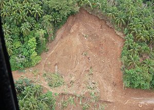
As an offshoot of the
Guinsaugon landslide, then President Gloria Macapagal-Arroyo on
February 22, 2006, directed the MGB to immediately conduct Rapid
Geohazards Assessment in Leyte and Biliran islands and to issue
appropriate warnings and recommendations to the local government
units. High priority was placed on these provinces because of the
recurrent occurrences of landslides in these areas.
Through the project,
the Mines and Geoscience Bureau aims to generate information on the
susceptibility to geohazards of every barangay and make information
available to concerned local government units and agencies responsible
for land use planning and development, disaster management and
mitigation.
The objective of the
project is to conduct assessment of barangays that are located at the
foot of slopes, mid-slopes and mountain ranges and to identify and
assess proposed and existing school and housing relocation sites.
The project also hoped
to provide the much needed geologic data to development planners and
disaster management experts so that consideration of the geologic
factors can be made during the critical decision making stage; and to
provide the necessary information and training to the concerned local
officials and populace so that they can take appropriate actions
during geohazards events.
The same assessment
was also conducted in Eastern Samar after completing the first batch
in Leyte and Biliran islands.
In February 2007, the
Mines and Geosciences Bureau presented to RDC 8 the results of the
Rapid Geohazards Assessment of Leyte,
Southern Leyte and Biliran.